
Met Office alert for Wales as first named storm threat looms
The Met Office has issued a 12-hour yellow weather alert for wind, covering large parts of south and mid-Wales. This alert is in effect from midnight on Thursday…
North Wales is bracing for severe weather conditions as the threat of the season’s first named storm looms over the region. Heavy rain and gusts exceeding 60 mph are expected to impact coastal areas, including Anglesey, in the coming days. The Met Office has issued specific warnings for parts of the country, urging residents to prepare for significant disruption.
The Met Office has issued a 12-hour yellow weather alert for wind, covering large parts of south and mid-Wales. This alert is in effect from midnight on Thursday until midday on Friday. During this period, strong winds are forecast to sweep across the region, posing risks to travel and outdoor activities.
In North Wales, the situation is particularly acute, with downpours and gale-force winds expected to intensify. By 1 pm on Friday afternoon, winds at Holyhead on Anglesey could reach speeds of up to 61 mph. Other areas across the region are likely to experience gusts of at least 48 mph or higher during the same timeframe.
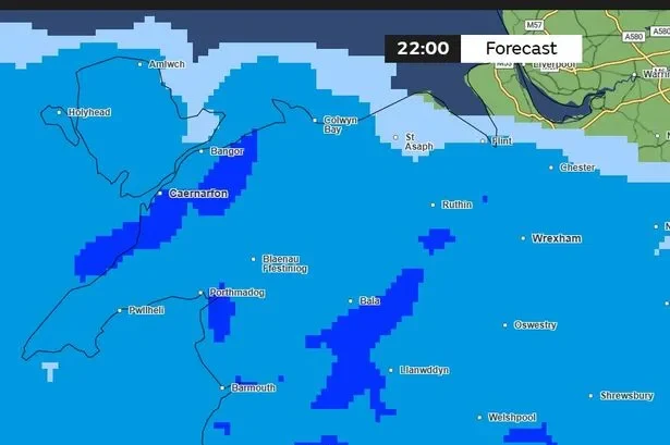
Weather maps indicate that heavy downpours will affect all parts of Wales by 10 pm on Thursday. Rain is expected to continue affecting the region in varying degrees throughout Friday morning. This persistent wet weather follows a period of turning wet conditions with coastal gales on Wednesday.
The forecast suggests a brief clearing before the weather turns showery with sunny spells into Thursday. However, lighter winds on Thursday are expected to give way to heavy rain spreading northeastwards into Friday. Strong winds are likely to accompany this shift, marking a significant change in the weather pattern.
Deputy Chief Forecaster for the Met Office, Tom Crabtree, highlighted the focus on a potentially deep area of low pressure. He stated: “An area of the forecast we’re particularly focusing on is the development of a potentially deep area of low pressure that could cross the UK overnight on Thursday and through Friday.”
Crabtree noted that this system has the potential to bring some strong winds, though the location of the strongest winds will be determined by the low’s position. He advised that at this stage, people should keep an eye on the forecast and be prepared for some unsettled weather at the end of the week.
If the weather front meets the specific conditions required for naming, it would be designated as ‘Storm Austen’. This name follows the storm-naming system used jointly by the UK, Ireland, and the Netherlands. The potential for this naming depends on the intensity and track of the developing low-pressure system.
Weather models suggest there is the potential for the jet stream to guide a deep area of low pressure across the UK by Friday. In addition to heavy rain, gales or even severe gales will be wrapped around the deep low. The precise impact will depend on the final track of the system as it approaches the British Isles.
Currently, most computer models take the centre of the low-pressure system across the south of the UK. The highest risk of disruptive winds would be over the southernmost parts of England and Wales, and possibly some eastern coastal counties of England later on Friday. Such a track would leave Scotland and parts of Northern Ireland with quieter weather conditions.
However, some computer models show the deep low taking a more northerly track. If this happens, then gales and disruption could be expected more widely, with impacts also in Scotland and Northern Ireland. Due to the uncertainty of the track of the potential storm, there is potential for the forecast to change.
It is important for residents to keep across any potential Met Office weather warnings as the situation evolves. The service has described the weather set-up into midweek as complex, with slow-moving fronts bringing areas of rain and fairly extensive low cloud over the hills. Varied wind speeds are expected during this initial phase.
Thursday may offer a window of drier weather and light winds, providing a brief respite before the storm system moves across England and Wales. By Thursday night into Friday, heavy rain and gales are likely, possibly turning to snow on higher mountains. Scotland may avoid this system and just see showers mostly in the west for Friday, wintry on tops.
Another Atlantic storm is then forecast to track further north over the weekend, bringing widespread severe gales to high terrain. This will be followed by heavy rain and then showery westerlies. Generally unsettled weather is likely to prevail to the end of October, indicating a prolonged period of challenging conditions.