
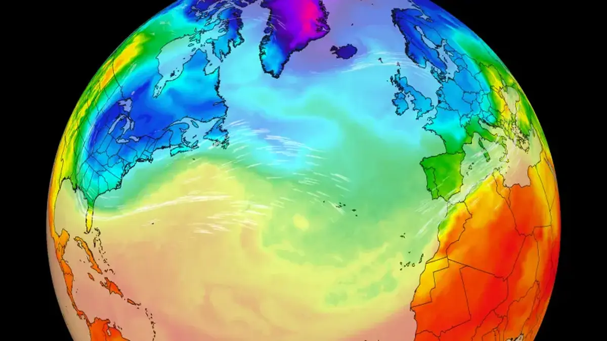
The polar vortex has broken down earlier than ever recorded, triggering a major sudden stratospheric warming event high above the Arctic. This unprecedented atmospheric shift is setting up a direct battle with a historically strong El Niño for influence over Northern Hemisphere winter weather. Meteorologists warn that the outcome remains uncertain, with conflicting forces determining whether cold air outbreaks will dominate or be neutralised by warmer global temperatures.
The polar vortex is a belt of strong winds in the stratosphere, located 10 to 30 miles above the Earth’s surface, which typically locks frigid Arctic air around the North Pole. It forms every autumn as the sun sets on the Arctic, playing a crucial role in shaping winter weather patterns across the Northern Hemisphere. For the past few weeks, however, this system has been weakening dramatically, with stratospheric air warming rapidly and causing the vortex winds to reverse direction.
This phenomenon, known as a major sudden stratospheric warming event, typically occurs between January and March. The previous earliest recorded instances happened on November 28 in both 1968 and 2025, making the current disruption exceptionally early in the season. Andrea Lopez Lang, a meteorologist at the University of Wisconsin-Madison, described the situation as “exceptionally unique,” noting that the timing defies standard historical patterns and complicates forecasting efforts significantly.
Scientists are investigating whether the strong El Niño phenomenon may have contributed to this early disruption, as some research links it to a weaker polar vortex. Simon Lee, an atmospheric scientist at the University of St Andrews, stated, “But we’re not sure yet,” acknowledging the lack of definitive causal evidence. The unprecedented nature of the event means historic data does not fully capture the current atmospheric conditions, making predictions challenging for meteorologists worldwide.
Parts of the US and Europe are experiencing their first taste of winter this week, with a blast of Arctic air spilling south from the disrupted vortex. This cold front arrived on Wednesday and is expected to last into the weekend, with peak cold conditions hitting most locations on Thursday or Friday. The snap will bring widespread frost to the Eastern US and Northwest Europe, marking a sharp break from the unusual warmth experienced during the recent summer and autumn months.
In the United States, nearly everywhere east of the Mississippi River is experiencing the coldest weather since spring. Most of the eastern half of the country is enduring temperatures 7 to 14 degrees Fahrenheit below mid-November averages, while similar anomalous cold is affecting northern Europe. Despite the intensity of the current cold snap, it is not expected to linger, with above-average temperatures set to return to the eastern US and other regions by next week.
Judah Cohen, an MIT climatologist, suggested that this week’s cold may only be the “appetizer,” with the more impactful “main course” still to come. He noted that the effects of a polar vortex disruption typically take a few weeks to filter down to the surface. Consequently, there is an increased risk of colder weather affecting both eastern North America and northern Europe in late November or early December.
However, polar vortex disruptions do not automatically translate into blockbuster cold, especially when occurring early in the season before Arctic cold has fully built. The presence of a super-sized El Niño adds another layer of complexity to the atmospheric dynamics. Lopez Lang described El Niño as the “big bully pushing the atmosphere in a certain direction,” suggesting its influence could overwhelm the cold air signals from the vortex.
Lopez Lang believes the impact of El Niño will be “so overwhelming” that any cold air experienced is unlikely to fall outside the range of a typical winter season. Amy Butler, a research physicist at NOAA’s Chemical Sciences Laboratory, echoed this sentiment, highlighting the dominant influence of the El Niño pattern. “The feature that stands out to me over the next month, is the higher chance of warm temperatures over the northern half of the US, likely related to El Niño,” she said.
Not all experts agree on the dominance of El Niño, with some challenging the assumption that it acts as an unstoppable force. Cohen argued that while El Niño is important, the presence of cold air will ultimately depend on the behaviour of the polar vortex. He emphasised that the interaction between these two major climate patterns is complex and cannot be simplified to a single dominant factor in the short term.
Jason Furtado, an associate professor of meteorology at the University of Oklahoma, added that global warming must also be considered in the context of potential cold air outbreaks. He noted that winters are warmer on average than they were just a few decades ago, changing the baseline for what constitutes extreme cold. “That means everything is relative when we talk about any potential cold air outbreak,” Furtado explained, highlighting the shifting climate norms.
NOAA’s Butler indicated that the polar vortex is expected to strengthen again quickly after the current disruption event. “It might be that this disruption doesn’t have much staying power,” she said, suggesting the immediate impact may be limited. However, the possibility of further disruptions later in the winter remains a significant area of focus for atmospheric scientists monitoring the stratosphere.
Lopez Lang expressed that she would not be surprised if another polar vortex disruption occurred later this winter. “And the next one might be the one that we actually have the impacts from,” she said, implying that the current event may be a precursor to more significant weather patterns. The timing and strength of any subsequent disruptions will be critical in determining the overall severity of the winter season.
This unique winter season provides scientists with a rare opportunity to observe whether El Niño is taking charge of the weather or if the polar vortex can still exert its considerable influence. The interplay between these two powerful climate phenomena is being closely monitored to understand their combined effects on global temperature and precipitation patterns. The results of this natural experiment could provide valuable insights into future climate variability.
Lopez Lang described the current atmospheric setup as an experiment, stating, “The atmosphere is setting itself up to be an experiment. She added, “I think is going to be really exciting to see,” reflecting the scientific interest in observing these rare conditions. The data collected during this period will be crucial for refining weather models and improving long-term climate predictions.
The early breakdown of the polar vortex highlights the increasing unpredictability of winter weather patterns in a changing climate. While the immediate cold snap is expected to be short-lived, the underlying atmospheric shifts may have longer-term implications for the Northern Hemisphere. Meteorologists continue to monitor the stratosphere for signs of further disruption or stabilisation.
The interaction between the polar vortex and El Niño remains a subject of intense scientific debate and research. Different models and expert opinions suggest varying outcomes, from mild winters dominated by El Niño to colder periods driven by vortex disruptions. This uncertainty underscores the complexity of forecasting winter weather in the face of multiple competing climate influences.
Reporting verified from official briefings and primary coverage by www.cnn.com.













Reader Discussion & Comments (0)
Join the conversation. All comments are moderated in accordance with our editorial standards.