

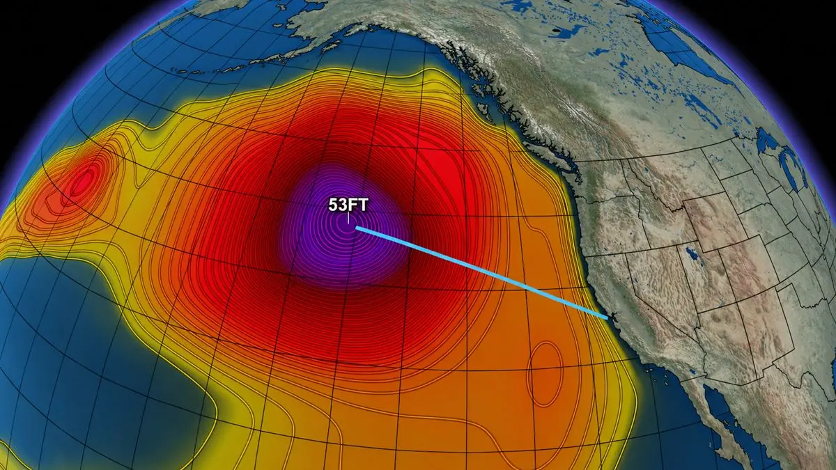
Forecasters have identified a “parade” of powerful storms funneling atmospheric rivers toward the California West Coast, bringing soaking rain, howling winds, and enormous surf. The latest social-media forecasts cite seas reaching 53 feet far offshore, though this specific figure has not been independently confirmed by official meteorological agencies.
Beyond Weather warned in a Facebook post that “A storm is expected to rapidly intensify about 1200 miles off our coast. The developing lows are expected to churn the Gulf of Alaska and send long-period northwest swell hurtling toward California.
FOX Weather describes a “relentless stretch of atmospheric rivers” affecting the Pacific Northwest, with the moisture stream gradually shifting southward. Western Washington could receive five to eight inches of rain or more, while a weakening system pushes into the Bay Area and Central Valley this weekend.
Surfline reports that “Modeled seas are expected to be somewhere between 45 and 50 feet within 1200 miles west-northwest of the San Francisco Bay Area. Southern California will see long period, more northerly angled swell build into select zones through Saturday with solid surf.
However, average spots see more size on Sunday as the period comes down some and swell direction shifts a bit more west. SURFER previously reported forecasts of 30-to-40-foot breakers along exposed Northern California beaches, setting the stage for potentially historic conditions.
The National Weather Service has issued high-surf warnings, forecasting 25-to-35-foot breaking waves for parts of Humboldt and Mendocino counties Friday into Saturday. Additionally, 25-to-30-foot surf is possible around San Francisco, posing significant hazards for coastal communities and visitors.
The agency also reiterated the golden rule: “Never turn your back on the ocean! Significant offshore wave heights could reach 25 to 30 feet Saturday, according to the agency. Those are averages of the highest third of waves—not the same thing as a reported 53-foot individual wave far out at sea.
For big-wave surfers, Maverick’s is the obvious question mark. Could this produce the season’s first serious session? Maybe, if swell direction, local winds and conditions cooperate.
But giant seas don’t automatically equal rideable waves, requiring precise alignment of oceanic factors.
The National Weather Service isn’t mincing words: “The risk of drowning is very high this weekend. Officials warn of sneaker waves, rip currents, coastal erosion and flooding worsened by elevated tides, urging the public to exercise extreme caution near the shoreline.
And this is only the beginning. Another powerful swell could arrive Monday. California’s winter wave machine is switching on.
Admire the spectacle—but from a safe distance. Unless, of course, you’re of the XXL skill level ilk.
Reporting verified from official briefings and primary coverage by www.yahoo.com.













Reader Discussion & Comments (0)
Join the conversation. All comments are moderated in accordance with our editorial standards.